
TORONTO, July 13, 2011 - An unmanned aerial vehicle (UAV) is flying around York University this week as part of an experiment designed to develop 3D technology that will provide a detailed picture of what’s happening in any city – whether it’s a concert or a crime, a traffic jam or the creative route a driver takes to avoid it.
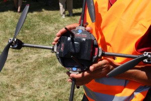 Weighing just 1.3 kg and measuring 80cm x 80cm x 30cm, the Aeryon Scout is flying no more than 60 metres off the ground, with a video camera focused on buildings, walkways, and trees, and the activity around them.
“Mapping of urban environments is typically done from aircraft flying high above the city, or vehicles on the ground (i.e. Google Streetview). But a lot of the important details lie somewhere in between,” says James Elder, a professor in both the Department of Computer Science & Engineering and the Department of Psychology at York University. “This vehicle – the Aeryon Scout – can acquire the high-resolution imagery of building facades required to reconstruct the detailed 3D structure of our cities.”
The research team has developed proprietary computer vision algorithms and a geospatial web mapping system to detect and track people and vehicles in real-time video streamed from city cameras, and then to project them as avatars into 3D city models. This allows the life of the city to be experienced in a natural 3D context, and viewed from any angle through web browsers. This is augmented by visual intelligence about the scene – for example, recognition of objects and activities as well as things like vehicle speed.
The vertical takeoff and landing missions, continuing today and tomorrow, are a small but important part of the ongoing GEOIDE project (http://icampus.apps01.yorku.ca/demo/index.html), a major initiative funded by the federal government ‘s Networks of Centres of Excellence program, and the provincial government’s Ontario Centres of Excellence.
The larger goal of the project is to develop a system that gives people a window into the life of a city, whether it is an urban planner watching how people are using city sidewalks, police or security officials trying to prevent crimes, or a tourist wondering what is happening at Dundas Square.
The UAV component of the project is a collaboration between Professor Claire Samson’s lab in the Department of Earth Sciences at Carleton University, Professor Elder’s Human & Computer Vision Lab, in York’s Centre for Vision Research, and Professor Gunho Sohn’s lab in the Department of Earth and Space Science and Engineering in York’s Faculty of Science & Engineering. Researchers from four other Canadian Universities are also involved in the project, along with Aeryon Labs of Waterloo, which designs and manufactures the Scout UAV, and Neptec of Ottawa, which is providing 3D structure from motion software technology. The Aeryon Scout is piloted (from the ground) by Tara Jones, as part of the requirements for her Masters in Earth Sciences from Carleton University.
See a VIDEO about the project:
httpv://www.youtube.com/watch?v=_RcdaIdRmHs
YorkUniversity is the leading interdisciplinary research and teaching university in Canada. York offers a modern, academic experience at the undergraduate and graduate level in Toronto, Canada’s most international city. The third largest university in the country, York is host to a dynamic academic community of 50,000 students and 7,000 faculty and staff, as well as 200,000 alumni worldwide. York’s 10 Faculties and 28 research centres conduct ambitious, groundbreaking research that is interdisciplinary, cutting across traditional academic boundaries. This distinctive and collaborative approach is preparing students for the future and bringing fresh insights and solutions to real-world challenges. York University is an autonomous, not-for-profit corporation.
Media Contact:
Janice Walls, Media Relations, York University, 416 736 2100 x22101 / wallsj@yorku.ca